California’s Sacramento-San Joaquin Delta is facing renewed pressure as persistent drought conditions, above-average temperatures, and increasing water demand reshape one of the nation’s most important freshwater distribution systems. The Delta supplies water to millions of residents while supporting agricultural production across the Central Valley, making reservoir storage, river flows, and water exports critical to both urban and farming communities.
During June 2026, the California Department of Water Resources (DWR) continued monitoring reservoir storage and Delta operations as snowmelt runoff declined earlier than expected following an unusually warm spring. Water managers have maintained close oversight of pumping operations feeding the State Water Project (SWP) and the Central Valley Project (CVP), balancing environmental protections with agricultural demand during peak irrigation season.
Farmers throughout San Joaquin, Sacramento, Stanislaus, and Fresno counties are adapting irrigation schedules as water deliveries become more closely tied to changing hydrological conditions across Northern California.
Reservoir Storage and Delta Operations Face New Challenges
California’s largest reservoirs entered summer with storage levels supported by winter precipitation, yet sustained heat during late spring accelerated snowpack melt across the Sierra Nevada. Faster runoff reduced the duration of natural inflows feeding rivers that ultimately replenish the Sacramento-San Joaquin Delta.
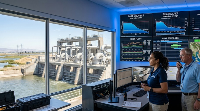
The Department of Water Resources continues coordinating releases from Lake Oroville, Shasta Lake, and Folsom Lake to maintain water quality standards within the Delta while supporting agricultural deliveries farther south. These operational decisions influence salinity management, fish habitat protection, municipal water supplies, and irrigation allocations at the same time.
Maintaining this balance has become increasingly difficult during prolonged warm periods. Higher evaporation rates reduce available storage, while agricultural water demand climbs as orchards, vineyards, and vegetable crops enter critical growth stages.
Current reservoir conditions and statewide operational updates are published through the California Department of Water Resources Water Conditions portal.
Agricultural Production Adjusts to Changing Water Deliveries
Water districts serving California’s Central Valley continue adjusting delivery schedules as Delta exports respond to reservoir operations and environmental regulations. Irrigation managers are coordinating more frequent communication with growers to maximize available supplies during periods of elevated demand.
Permanent crops such as almonds, pistachios, walnuts, and vineyards require carefully managed irrigation timing to protect long-term productivity. Unlike annual field crops, orchards cannot simply remain fallow during dry years without risking permanent economic losses.
Growers are increasingly combining satellite imagery, evapotranspiration models, and soil moisture monitoring to determine irrigation schedules with greater precision. These technologies allow individual fields to receive water according to actual crop demand rather than fixed calendar intervals.
Many producers are strengthening their long-term planning through soil moisture monitoring strategies, allowing irrigation decisions to reflect changing environmental conditions throughout the growing season.
Delta Water Quality Remains a Central Management Priority
Freshwater movement through the Delta influences far more than irrigation deliveries. River flows help limit saltwater intrusion from San Francisco Bay, protecting water supplies used by both agricultural districts and municipal utilities.
Periods of reduced freshwater inflow require careful coordination among multiple state and federal agencies. Pumping operations cannot simply maximize exports without affecting water quality standards established for fisheries and downstream users.
The California Department of Water Resources and the U.S. Bureau of Reclamation continue evaluating operational scenarios that preserve environmental requirements while maintaining dependable deliveries whenever hydrological conditions permit.
Additional technical information regarding Delta operations is available through the U.S. Bureau of Reclamation California-Great Basin Region.
Precision Agriculture Supports Irrigation Efficiency
Technology adoption continues accelerating across California agriculture as water availability becomes more variable. Precision irrigation platforms combine weather forecasts, field sensors, satellite imagery, and GPS-guided equipment to reduce unnecessary applications without sacrificing crop development.
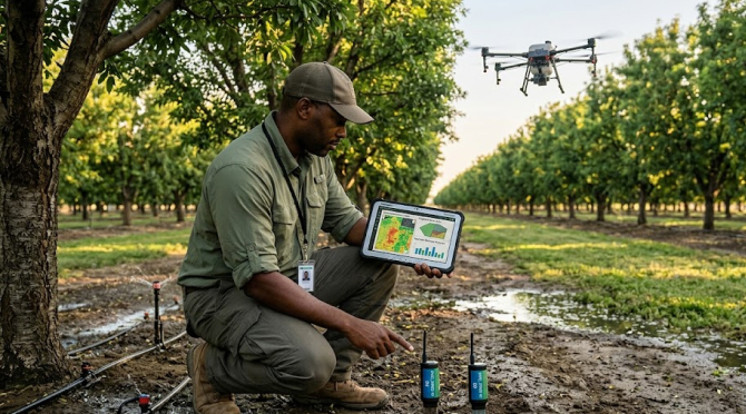
Large farming operations increasingly rely on digital field maps that divide individual properties into irrigation management zones. Soil texture, crop type, slope, and historical yield data all contribute to irrigation recommendations generated throughout the season.
Remote sensing has become particularly valuable during heat events. Thermal imagery collected by drones and satellites identifies crop stress before visible symptoms appear, allowing irrigation managers to prioritize areas requiring immediate attention.
| Precision Technology | Primary Function | Farm-Level Benefit |
|---|---|---|
| Soil moisture sensors | Measure root-zone water availability | More accurate irrigation timing |
| Satellite imagery | Detect crop stress | Earlier management decisions |
| Variable-rate irrigation | Apply water by management zone | Lower water consumption |
| GPS field mapping | Improve irrigation planning | Better resource allocation |
These technologies continue attracting investment as growers seek practical methods for maintaining productivity under increasingly constrained water supplies.
Groundwater Dependence Continues Across Central Valley Farms
Surface water limitations often lead producers to increase groundwater pumping where infrastructure is available. California’s Sustainable Groundwater Management Act (SGMA) has introduced additional oversight for groundwater basins experiencing long-term overdraft, encouraging local agencies to develop sustainable extraction plans.
Groundwater remains an important supplemental resource during dry periods, though deeper pumping raises operational costs through increased electricity consumption and well maintenance requirements.
Several groundwater sustainability agencies within the San Joaquin Valley continue implementing monitoring programs that combine groundwater measurements with satellite observations of land subsidence. These datasets provide long-term insight into aquifer conditions while supporting future management decisions.
Agricultural economists note that farms capable of integrating surface water deliveries with carefully managed groundwater supplies generally maintain greater operational flexibility during variable hydrological conditions.
Infrastructure Modernization Shapes Long-Term Water Reliability
Water infrastructure investments remain a central component of California’s long-term drought response strategy. Canal modernization, reservoir improvements, groundwater recharge projects, and conveyance upgrades all contribute to improving system efficiency.
Modernization projects seek to reduce conveyance losses while improving operational flexibility during periods of fluctuating runoff. Digital monitoring systems installed throughout canals and pumping stations provide operators with continuous information regarding flow rates, water quality, and infrastructure performance.
Collaboration among irrigation districts, state agencies, universities, and agricultural organizations continues expanding research into water-use efficiency, climate adaptation, and improved forecasting models.
The combination of engineering improvements and field-level technology adoption reflects a broader transition from reactive drought management to continuous resource optimization supported by data collected throughout California’s interconnected water system.
Farming Decisions Continue Evolving With Hydrological Conditions
California agriculture has operated through recurring drought cycles for decades, yet current management strategies rely far more heavily on digital information than previous generations. Water availability is now evaluated alongside weather forecasting, satellite monitoring, crop modeling, and groundwater planning to support day-to-day operational decisions.
The Sacramento-San Joaquin Delta remains the center of this interconnected system. Reservoir operations, environmental regulations, irrigation infrastructure, and precision farming technologies all influence how water moves from Northern California watersheds to some of the country’s most productive agricultural regions.
As 2026 progresses, growers, irrigation districts, and water agencies will continue adapting operational strategies based on changing reservoir conditions, evolving weather patterns, and the long-term objective of maintaining reliable agricultural production across California’s diverse farming landscape.