The U.S. Department of Agriculture (USDA) and NASA are expanding their partnership to improve the quality, timeliness, and usefulness of agricultural statistics used across the United States. On October 24, 2026, Agriculture Secretary Brooke Rollins and NASA Administrator Jared Isaacman signed a memorandum of understanding at the University of Alabama in Tuscaloosa, establishing a framework for closer cooperation in Earth observation, geospatial analytics, statistical methods, and advanced data technologies.
The agreement supports the USDA’s broader data modernization effort, which aims to improve acreage and yield estimates, reduce unnecessary reporting burdens on producers, and strengthen the information used by farmers, agricultural businesses, researchers, and policymakers. Satellite observations, crop models, machine learning, and improved data infrastructure are among the tools the agencies will explore.
For farmers, the potential benefits extend beyond technology. More reliable estimates of planted acreage, crop conditions, and expected yields can influence marketing decisions, storage plans, insurance assessments, and expectations for commodity supply. However, the agreement establishes areas for collaboration rather than guaranteeing immediate forecast improvements. Its success will depend on the quality of the data, the validation of new methods, and how effectively the agencies combine satellite observations with information collected directly from producers.
What the USDA–NASA Agreement Covers
The memorandum of understanding signed on October 24 establishes a framework for cooperation between the two federal agencies. According to the official USDA announcement, the partnership will focus on integrating Earth observation, geospatial analytics, and statistical methodologies into agricultural data operations.
NASA brings expertise in satellite observations, Earth science, computational analysis, and large-scale environmental datasets. The USDA contributes agricultural statistics, knowledge of crop production systems, established reporting programs, and direct relationships with farmers and ranchers.
Combining those capabilities could help the agencies examine agricultural conditions across large areas while retaining the statistical methods needed to produce reliable national and regional estimates. The agreement identifies several potential areas of cooperation, including remote sensing science, crop and yield modeling, geospatial data engineering, and machine learning.
The agencies also plan to examine how NASA’s Earth science missions and data products can better support USDA statistical requirements. This could involve improving access to satellite archives, integrating different datasets, and reviewing the algorithms used to estimate planted acreage, harvested area, crop conditions, and disaster impacts.
The memorandum does not announce a specific funding allocation, a new satellite mission dedicated to U.S. agriculture, or a firm deadline for delivering revised crop estimates. Instead, it creates a structure through which the departments can align technical priorities and investigate methods that support agricultural statistics.
That distinction matters for producers. The announcement establishes an institutional commitment to modernization, but measurable benefits will require testing, implementation, and evidence that new approaches improve the accuracy or timeliness of existing reports.
Why USDA Crop Estimates Matter to Farmers and Commodity Markets
USDA crop estimates influence decisions throughout the agricultural supply chain. Farmers use production forecasts when deciding whether to sell grain at harvest, store it for a later date, or manage expected cash flow around input payments and debt obligations. Grain merchants, processors, exporters, and commodity traders also use estimates to assess potential supplies and market conditions.
The USDA’s National Agricultural Statistics Service (NASS) publishes information on planted acreage, harvested acreage, yields, production, and other indicators. Its Crop Production reports and annual surveys help establish a common statistical reference for a market in which individual producers have different field conditions, yields, and production costs.
When acreage or yield estimates change, expectations for total production can change as well. A revision to a major crop estimate may influence prices, storage demand, transportation requirements, and purchasing decisions. The direction and size of any market reaction depend on the revision, existing expectations, global supply conditions, demand, and other factors.
Concerns about data quality have added urgency to the modernization effort. On September 1, 2026, Rollins announced the USDA Data Modernization Plan at the Farm Progress Show in Boone, Iowa. The plan outlined four priorities: improving the reporting experience, enhancing acreage and yield estimation, integrating data and technology platforms, and expanding trust and transparency with producers.
The plan also proposed a pilot to evaluate improved satellite imagery, geospatial tools, crop models, and other technologies alongside essential producer-reported information. The October agreement with NASA gives that initiative a framework for accessing additional Earth observation expertise and coordinating technical work.
For farmers, the objective is not simply to replace a survey with an image from space. It is to develop estimates that better reflect actual production conditions while maintaining the statistical reliability required for national agricultural reporting.
How Satellite Imagery Could Improve Acreage and Yield Estimates
Satellite data can help analysts observe agricultural landscapes over time. Depending on the sensor and the conditions being measured, satellite imagery can reveal differences in vegetation, crop development, surface moisture, and the effects of drought or other environmental stress.
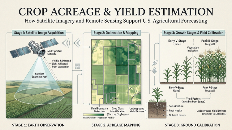
Repeated observations are particularly useful because a single image captures only one point in a crop’s development. A sequence of images can show how vegetation changes during a growing season and help analysts compare patterns across fields and regions.
For example, satellite observations may help distinguish areas showing healthy crop development from fields experiencing stress. When combined with crop calendars, weather records, soil information, and statistical models, those observations can support estimates of crop condition and possible production outcomes.
Acreage estimation presents a related opportunity. Geospatial tools can help identify agricultural land, classify crop types, and assess the area planted to particular crops. These methods could complement survey responses and other administrative data used by the USDA.
Yield estimation is more complicated. Vegetation signals can provide information about crop development, but they do not directly measure the final quantity of grain harvested from every field. Yield depends on multiple factors, including crop variety, planting dates, soil characteristics, water availability, pest pressure, weather during critical growth stages, and management practices.
A field that appears healthy in satellite imagery may still experience losses before harvest. Conversely, a crop showing stress at one point in the season may recover if conditions improve. Statistical models must account for these differences rather than translating imagery into production estimates without further checks.
NASA’s Earth science capabilities could help the USDA evaluate how satellite observations and model outputs contribute to its estimates. The agencies can also examine how uncertainty should be measured and how new indicators should be validated against reliable field information.
Additional information about NASA’s Earth observation work is available through its Earth science program.
Where Artificial Intelligence and Machine Learning Fit
Artificial intelligence and machine learning are potential components of the partnership, but their value depends on the agricultural questions they are used to answer and the quality of the data supplied to them.
Machine-learning systems can process large collections of satellite observations, weather measurements, geospatial layers, and historical crop records. They can identify patterns that may be difficult to evaluate manually across millions of acres and multiple growing seasons. These patterns may help analysts classify crops, detect changes in vegetation, or identify areas that warrant closer examination.
A model could, for example, compare current satellite indicators with historical observations from similar stages of crop development. Combined with weather and soil information, the analysis could help estimate whether current conditions resemble years associated with higher or lower yields.
Such estimates would still require validation. Historical relationships do not always hold under unusual weather conditions, changing crop varieties, new farming practices, or different regional production systems. A model trained primarily on one set of growing conditions may perform less reliably when applied elsewhere.
The USDA and NASA have identified potential cooperation in machine learning and advanced data analysis, including the review of algorithms used for crop indicators, yield models, planted and harvested acreage, and disaster assessment. Their work may also examine bias correction, uncertainty quantification, and validation using statistically sound samples and ground data.
These safeguards are essential because an algorithm can produce precise-looking results without guaranteeing that those results accurately represent field conditions. Independent testing, transparent methods, and comparison with observed agricultural outcomes should remain central to any operational use.
For Agheiro readers interested in modern agricultural planning, this partnership illustrates how digital tools can support farm decisions when they are integrated with practical field knowledge rather than treated as a substitute for it.

Reducing the Reporting Burden Without Losing Farmer Input
Satellite technology is only one part of the USDA’s modernization strategy. The department also wants to improve how it collects information from producers, including through better digital reporting tools, expanded use of appropriate administrative data, and opportunities to prefill information where suitable.
These changes address a longstanding challenge in agricultural statistics: reliable estimates depend partly on participation by farmers and ranchers. Producers have direct knowledge of planting decisions, crop conditions, harvested acreage, and other details that may not be fully visible from space.
A satellite may identify a likely crop type or indicate that vegetation is developing unevenly, but it cannot independently confirm every management decision or explain all the reasons behind a field’s performance. Producer-reported information remains valuable for checking remote observations and interpreting conditions that cannot be reliably inferred from imagery alone.
The September modernization plan also emphasized trust and transparency. The USDA said it would continue protecting producer privacy, explain why information is requested and how it is used, and provide clearer communication about reports, methods, response rates, and data limitations.
This is important because improved technology will not automatically resolve concerns about data collection. Producers need confidence that the information they provide is handled appropriately and that statistical reports reflect sound methods.
If digital reporting becomes easier and duplicate requests are reduced, participation could benefit. However, any improvement in response rates or data quality will need to be measured rather than assumed.
Monitoring Drought, Weather Damage, and Other Agricultural Risks
The USDA–NASA partnership also has implications for monitoring natural hazards. Drought, flooding, extreme heat, and other weather events can affect crop development across large areas, sometimes before the full extent of the damage is apparent in production statistics.
Satellite observations can help analysts monitor vegetation changes and other environmental indicators associated with crop stress. When combined with weather observations, soil information, and agricultural models, these data may improve the assessment of where damage is occurring and which areas need closer review.
For instance, a prolonged period of limited rainfall may affect crops differently depending on soil type, irrigation access, planting dates, and the stage of crop development. Geospatial analysis can help identify regional patterns, while field reports and other data provide additional context.
More timely assessments could help agencies evaluate disaster impacts and inform decisions about agricultural assistance or risk-management programs. Insurers, lenders, and producers may also find improved regional information useful when evaluating exposure to weather-related losses.
Nevertheless, satellite-based indicators are not equivalent to a confirmed crop-loss assessment. Determining the actual effect on yields or farm finances requires additional evidence, and the relevant procedures vary by program. The agencies’ work will need to establish where remote observations add dependable information and where traditional reporting or field verification remains necessary.
What the Partnership Means for U.S. Agriculture in 2027
The next stage is implementation and evaluation. The memorandum outlines areas in which the agencies intend to cooperate, but the public announcement does not specify a complete deployment schedule, a set of new forecast release dates, or quantified improvements in yield-estimate accuracy.
Producers should therefore view the agreement as an important step in the USDA’s modernization process rather than evidence that future crop reports will immediately become more precise.
Progress can be assessed through several practical measures: whether acreage estimates improve when compared with reliable field data, whether yield models perform consistently across different crops and regions, whether disaster assessments become more useful, and whether the USDA can produce information more efficiently without reducing statistical quality.
Transparency will also matter. Clear documentation of methods, uncertainty, validation results, and the role of producer-reported information would help farmers and market participants judge whether new tools are delivering meaningful improvements.
The agencies’ ability to combine NASA’s Earth observation resources with the USDA’s agricultural expertise creates opportunities for better-informed decisions across the U.S. farm economy. But the ultimate test will be the quality of the information delivered to producers and the public, not the sophistication of the technology alone.
As the partnership develops, its most consequential contribution may be a more integrated approach to agricultural statistics—one that uses satellite data and machine learning to strengthen established survey methods while preserving the local knowledge and direct reporting that remain essential to understanding American agriculture.